Introduction
North Korea is one of the most isolated countries from the rest of the world. Although bordered by China to the North and South Korea to the south, those borders are heavily guarded twenty-four hours a day by military on either side. No one gets in, and no one gets out. The country is so isolated because at the end of the Korean war and the splitting between the North and South, North Korea became a separate country ruled by Kim Il Sung and later his son Kim Jong Il. The regime is very strict. People are taught to fear and love the great leader Kim Il Sung and the dear leader Kim Jong Il but also fear them. If they do not say “great leader” or “dear leader” when addressing Kim Il Sung or Kim Jong Il they will be punished according to former prison guard Ahn Myong Chol (NBC). If they do not agree with the current regime, (and many North Koreans don’t) they will be put into prison camps along with all of their related family members. The North Korean regime uses the prison camps as a tool to scare people into following the laws of the great and dear leader.
The biggest issues today are the concentration camps that the North Korean government run. One type of camp, a kwan-li-so, or translated as political prison camps, or concentration camps are run by the NSA. These camps hold ex-political figures, people who have broken the law and have committed crimes against the nation and pose a threat to the regime. According to the National Geographic documentary, Inside North Korea, kwan-li-so 22 holds the family members of people who have committed political crimes. The people in the camps are treated very poorly, beaten, not fed well, and are often tortured to death. In a survey of North Koreans that have escaped the penal system and have sought refuge in China and South Korea, 60% of respondents witnessed executions, 90% witness forced starvation, and 20% witness death by torture (Noland and Haggard 22) This is a problem because it is a crime against humanity to treat people like this. It also shows something about the government. This system makes the people fear the leadership or they will be put in labor camps if they disobey. The biggest problem is, when people fear and want to get out, they try to escape and are repatriated back to North Korea or many times killed.
North Korea denies to the rest of world the fact that they have concentration camps and that they do not do such things to their own people. However, these camps are very real according to articles found on surveys from refugees living in South Korea and China who have confirmed the way people are treated in the camps. Satellite images have also suggested the location of the camps and there is an estimate of about 200,000 people in the different camps scattered throughout the country. I have found personal blogs and article from people who have had access to Google Earth imagery and have studied locations on camp 22 mostly. The most information I have come across is a blog by "Joshua" on OneFreeKorea.com. Furthermore, National Geographic documentary interview with Ahn Myong Chol, a former guard at Kwan-li-so 22 provides a hand sketch of the coal mine where the labor workers worked.
Problem statement: Where is the specific location of Camp 22 (i.e. where does the fence line fall) and how big is it actually compared to the estimates? And what types of buildings are inside of the camp? Also, have there been any changes within the camp in the past years?
Methods.
Camp 22 is thought to be the largest of all camps housing possibly 50,000 North Korean prisoners. In order to look at this site I will first need to locate it. It is thought to be tucked away in some mountain ridges in the Northeastern portion of North Korea by the border of China and Russia. The general location of this camp is about 20 km from the city of Hoeryong, and surrounded by the villages Wŏn-dong, Ssŏgŭndari, Kulsal-li, Haengyŏng-ni (headquarters of the camp), Naksaeng-ni and Chungch’u-dong according to Wikipedia.
Because this is such a small site, only the use of high resolution images is helpful. I am using Google Earth images to show the area. First, I digitized the area of the supposed place of the camp. I did this by finding the fence near the border of China and the north of the country. The fence was easy to find because it looked like a sort of road-like line, but every 1200 feet or so was a guard post, very visible in GoogleEarth. By following the fences with the guard posts I traced the outline of the camp and found entrance locations. With Google Earth and ArcGlobe, I have also created reference maps to show the location of the camp in relation to China and Russia, the different provinces and the different cities.
I also use different spatial data like Landsat satellite imagery of the region, a 3D model to show the mountainous terrain and nightlight imagery. I created a 3D image of the camp to show its location tucked away in the slopes of the mountain. I used a DEM downloaded from Global Land Cover Facility and layered a Landsat image of my study area with the ENVI 3D converter (vertical exaggeration at 7). The nightlights will help me to determine how much light (if any) is being used at this specific region. The nightlight imagery is a world night light data image from Dr. Gillespie that I scaled to only show the region of Camp 22. Also, I would like to see whether or not the camp has changed in greeness during the period of famine, (1994-1998). I downloaded Landsat imagery of the region, path 115, row 030, from dates: 10-17-1992, 8-31-2001, and 9-22-2006 (these images were the only good images I could find that were close enough to the time period without having more than 30% cloud cover. Due to the location in the mountains, almost every satellite image I found had more than 50% cloud cover). With these images, I created an NDVI using the 4-3-4 bands into the blue, green and red bands slots in ENVI to create an infradred image and then Created the NVDI index using the tool in the transform menu. I then created a change detection for the 1992-2001 period and 2001-2006 period by using the compute change detection and inputing the earlier date first and the later date second.
Results

Camp 22 is located in the northern region of North Korea near the border of China and Russia. It is located in the North Hamgyong province.

As you can see closely, the camp is really close to the border of China. It is located in the county of Hoiryong, and its bordering counties are Onsong and Saepyoi to the north and northeast, Undok to the west, Chongjin, Puryong and Musan to the south. The people who live in the rural cities in the counties bordering the camp go about their daily lives just miles away from nightmare-ish reality.

Here is a satellite photo with the digitized border of Kwan-li-so 22, picture viewed in ArcGlobe. As you can see how close it is to the border of China. According to former prison guard Ahn Myong Chol, the political prisoners of Camp 22 were involved with digging tunnels under the borders. I believe that this is the reason as to why the camp is so close to the Chinese Border.

Here is the 3D image of the area with the September 22, 2006 Landsat satellite image. The camp
is located within the area that in in the crevasses of the mountains (the whiter regions). As you can see, the camp is tucked away or sort of hidden from the rest of the country because it is in mountainous terrain.

Here is the look at the camp from the Chinese border. The vertical exaggeration is 7 in this 3D image. As you can see, while looking towards North Korea from China, one cannot see the specifics of the camp because the mountainous terrain provides a geographic visual barrier. One of the main reasons the camp was put in this region is because it can be concealed from the rest of the world, that is until satellite imagery became available through Google.

Here is the nightlight image for the area of Kwan-li-so 22. As you can see that within the area of the Camp there is no night light at all. This could be because North Korea is trying conceal their location of the camp from the rest of the world or because, like most places in the country, they just do not have enough energy to keep their lights on at night. However, from looking at only the night light image, there is no conclusive evidence to show the existence of Camp 22.

Here is the change detection image from the time period of October 1992 (around the period of the start of the famine of North Korea). and August 2001. The areas in red show increased greeness and areas in blue have decreased greeness. This image shows that all of the red areas around the camp have gotten greener, however it is significant to note that inside the camp, the areas have gotten less green. This may be because there was an expansion of the camp or an increase in workers farming or mining as labor during this time period. I believe that there may have been an increase in workers during this time period because of the effects of the famine and economy on people's wellness. Because of hard times, people may have been more inclined to try to leave the country and become political enemies causing the enslavement of their family members. It also could be a change in the landscape due to over farming or exploitation of the land. (Note: there are some discrepancies in the images I had available. Because images for this region were hard to find without clouds, the months and years in which I had to chose was limited the change in greeness may be in part because of the differences in season. According to Library of Congress, August in one of months seeing the most rainfall)

Here is the change detection image from the period of August 2001 and September 2006. As you can see the region has gotten significantly less green overall. The darker blue areas represent a higher degree of decrease in greeness and are shown in the centers of where features of the camp lies. The most decrease in greeness occur within the crevasses of the mountains where the political prisoners work in the coal mines and farm the land. Again, like in the change detection above, I believe it is less green showing a growth in the camp workers. I believe this is because the camp has grown into one large camp that now contains some prisoners from other camps that were transferred here. It is known that there used to be more camps, around 14, that have consolidated into 5 large camps, camp 22 being the largest (Noland and Haggard 7). Therefore, there was a decrease in greeness due to the increase of coal mining and farming of the land due to the increase in workers in Camp 22.
(Note: I was unable to get my digitized camp 22 Kml file to a shapefile to project it into the change detection image)
Specifics of Kwan-li-so 22

This is the headquarters of Camp 22. In the center of the map is a white building said to be Kim Jong Il memorial hall. This map also features family living quarters and guard areas such as night guard posts, armories, various offices and restrooms.

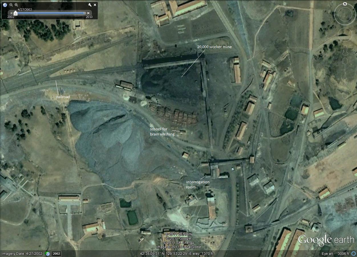
Here is a main district of the camp. This is the portion that contains the coal mine were Ahn Myong Chol says 20,000 people work here. As you can see at the top of the image, there are two roads that come in from outside the eastern fence, intersect and then go into the area. One of these roads is a railroad that transports coal in and out of the coal mine, the other is a road from the main entrance to the camp.
Here is the image of the 20,000 worker mine the former guard draws in the National Geographic documentary. Based on his drawing, I was able to label some of the features he did. As you can see I have located the school for brain washing and the interrogation room as well as the railroad that leads to the 20,000 worker mine.


Here is the housing just southeast of the coal mine. I wanted to make note the changes in the housing configuration from 2002 to 2010. Notice that in the top-left corner of the picture in 2002 there are rows of housing that are missing in 2010. Those housing have been relocated in the lower right portion of the area. However, more housing was lost than was gained. This could be because of budget issues and the failing North Korean economy. The guards and the camp could be putting higher concentrations of people in the housing. Also, some people could be more spread out. It is suggested that the camps are set up so that there is scattered housing separated from the rest of all other housing. I believe this to be because the guards do not want an uprising or for people to form coalitions against the regime in their own prison camp.


In the case of the area above, there is a building missing in 2010 that was there in 2002. This could have been for the reason mentioned above; the economy has gotten worse in North Korea and the guards budget has run thin. Also, the case could be that the building was no longer needed, whatever specific that building was.


Above is just showing another example of where the camp has grown in the past 8 years. There is an additional building I have located that was not in the 2002 image. Therefore, this could show that the camp is indeed making new additions to the camp many to accommodate more guards, prisoners of activities, depending on the buildings function.
There are many important features of the camp that make this area noticeably a camp.


The fences above can be seen easily from the satellite imagery provided by GoogleEarth as well as the guard posts that appear ever 1200 feet or so. The guard posts and fence lines are images of the eastern border of the camp. Unfortunately, GoogleEarth does not provide very good satellite images of the western areas.


The images above are two of the entrances to the camps and the ones that are most clear in the satellite imagery from GoogleEarth. The first image is the main entrance located on the eastern border of the camp just east of the coal mine. In the image, the main entrance is located at the top of the picture. Below is the train entrance. Both of the these road lead to the coal mine camp shown earlier. The second image is imagery of the southern entrance. You can clearly see the road from outside of the gates to inside of the camp. This road leads to the center of the camp.
Discussion
As the results show, the prison camp is indeed located in the province of North Hamgyong, near the border of China. It is located there for two reasons that I have concluded from the evidence I have provided: 1) because of the mountainous terrain it is able to stay hidden from foreigners and 2) it was a camp used to create tunnels under the Chinese-North Korean border. Additionally, I have concluded that over time, the general region has gotten less green and this in part may be due to the increase in political prisoners in the camp. Because of the increase in the prisoners, there is and increase in the amount of work being done in the mines and on land, thus having an impact of the growth of photosynthetic plants. Therefore, over the span of 13 years, the areas in which the camp resides (where the buildings and housing are and where the political prisoners work) has gotten less green.
Furthermore, the specifications of Camp 22 can be compared to that of what I have found on online sources. Some blogs I have come across have also looked at Camp 22. Many of my findings have come to the same conclusions as some blogsites as well and have added to my discoveries. For example, Joshua on One Free Korea had discovered some ditches along the fence line of the camp and concluded that they were man traps set up to make escape from the camp much more difficult. That is something that I did not come across. However, Joshua did not look for any changes in the camp as I did. He only looked at specific features in the camp. Also, my digitized border of camp 22 was pretty accurate in comparison to his size of pointed out guard posts up the eastern border. However, my only concern is that this camp is estimated to be 31 miles long and 25 miles wide (Noland and Haggard 7) whereas my digitized border following the fence line is only 14 miles long and 8 miles wide.
In this project there were quite a few limitations. As noted before, the area of the camp is located in the mountains. This made it very difficult for me to find an image that did not have clouds. (However, if you look very closely in one of my images, there are a few clouds still.) Many of the images were 60% or more cloud cover, so I could not use those. Of the images that did not have as much cloud cover, they were in different seasons. The difference in seasons could have a major effect on the NDVI change detection outcome and could cause the results to be flawed in some ways. Additionally, GoogleEarth is really the only good high resolution imagery I have for North Korea, however there were some areas in the camp that did not have sufficient high resolution images. Therefore, I was unable to study those areas. Therefore, any future avenues of research is to go into the field and find out for myself, however the problem with that is that I am not allowed to go into North Korea and especially not allowed to see the political prison camps. Therefore, the only way for me to get extra knowledge is to talk to a former guard or survivor and have that person point out the specific buildings and functions of each building in the camp.
References
Ahn Myong Chol. (Performer) (2006). National geographic: Inside North Norea [DVD].
Camp 22. (n.d.) In Wikipedia. Retrieved November 30, 2011 from http://en.wikipedia.org/wiki/Camp_22
Haggard, S., & Noland, M. (2009). Repression and punishment in north korea: Survey evidence of prison camp experiences. East-West Center Working Papers, 20, 1-29.
Joshua. (2007, Feb 18). Holocaust now: Looking down into hell at Camp 22. Retrieved from http://freekorea.us/?p=6519
Library of Congress. (2007). Country profile: North korea. Retrieved from http://lcweb2.loc.gov/frd/cs/profiles/North_Korea.pdf
NBC. (2003, Jan 15). Former guard: Ahn myong chol. Retrieved from
That is a perfect intelligence analysis of North Korea! Thank you for picking North Korea cause I have learned a lot! You know there are humanitarian groups that are interested in this type of analyses. Very interesting geography! Sincerely DRG
ReplyDelete